


Helios

JPS73
User
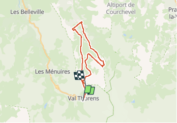

Length
23 km

Max alt
2925 m

Uphill gradient
2692 m
Km-Effort
58 km

Min alt
1683 m

Downhill gradient
2249 m
Boucle
No
Creation date :
2024-12-30 09:42:41.699
Updated on :
2024-12-30 16:36:04.389
1h38
Difficulty : Very easy

FREE GPS app for hiking
 SityTrail
IGN / Geographical institutes
SityTrail Plus
The world is yours!
About
Trail Alpine skiing of 23 km to be discovered at Auvergne-Rhône-Alpes, Savoy, Les Belleville. This trail is proposed by JPS73.
Positioning
Country:
France
Region :
Auvergne-Rhône-Alpes
Department/Province :
Savoy
Municipality :
Les Belleville
Location:
Saint-Martin-de-Belleville
Start:(Dec)
Start:(UTM)
310401 ; 5018569 (32T) N.
Comments